Day 10 - Saxon, WI to International Falls, MN, MN - 550 Miles
It started out as a confusing day as I was having trouble keeping track of the time as I crossed over into the Central Time Zone. So when I thought I was getting a late start, it actually was an hour earlier. Yeah. It was a blessing as the day was jammed packed with very interesting stops.
This was also good cuz today was a long driving day! 550 Miles but worth it. I even saw 3 black bears frolicking on the side of the road near Atikokan, ON, right outside of Quetico Provincial Park. What a sight! But alas I was slow on the uptake and did not get a picture.
 |
| A big red apple sitting in a field along the way |
It was off to the shores of Gitchigami and the Wild Archipalego of the Apostle Islands National Lakeshore, a group of 22 islands in Lake Superior off the shore of the far northwest corner of Wisconsin. The area has been inhabited for hundreds of years by the Ojibwe Natives, who are to a large extent living off the land in self-sufficieny. Fishing, stone quarrying and lumbering are the commercial activities of the area. Quarrying for sandstone became especially common here after the Great Chicago Fire of 1871 spurred the demand for building materials.
 |
| Apostle Islands National Lakeshore |
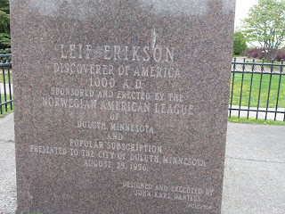
Then it was off to Duluth, MN and the boyhood home of Bob Dylan. Leif Ericksen supposedly has a viking ship moored at the lake’s edge, but it was dry-docked for restoration today. Had to settle for a statue of him in his park.
 |
| Bob Dylan's boyhood home - Duluth, MN |
 |
| Leif Erikson statute |
Next it was up the western side of Lake Superior to Grand Portage, MN, which also sits on the Canadian border.
 |
| Display at Grand Portage National Monument |
Grand Portage National Monument, again under the auspices of the National Park Service, preserves the history and pays tribute to the “Voyageurs” – French Settlers and the Ojibwe Natives in their relationship of trading furs and other goods in the 1700s. The French Settlers were running a route from Europe to Montreal and across Canada & the US to western Canada. The Great Lakes and rivers provided most of the route via canoes; however, in this area now called the Grand Portage was a series of waterfalls and rapids which were not navigable. A land route of about 20 miles was established around this section of the Pidgeon River and European settlers carried the furs, liquor, household goods and other cargo on their backs as Sherpas for these 20 miles, thus getting the name meaning “The Great Carrying Place”.
Took a shortcut (I think) through Canada to International Falls, MN, instead of backtracking into the lower portion of Minnesota and then heading west and north.
 |
| All rivers flow north..except |
It probably was the shortest route. Gassed up the RV before crossing the border. Once on the road in Canada, I didn’t see anything for 5 hours... no gas stations, stores, restaurants, billboards, nothing...nada. Except for 3 bears frolicking on the side of the road and a couple dozen signs warning of Moose crossings.
Finally called it a day at Arnold's Campground, International Falls, MN


No comments:
Post a Comment